Download your free copy of GSD Calculator.
You may request a download link for latest version of GSD Calculator here, input your email address in the field below.
Check also your SPAM folder for email.
Latest version for Windows 10/11 Users:
Latest update:
- Leica TerrainMapper-3 included (Hybrid LiDAR sensor)
previous updates:
- minor changes
- CCD-Type designator for Bayer-pattern CCD changed.
In order to reduce disadvantages for manufacturers using Bayer-pattern sensors, I have removed the term „50% usable resolution“ from Bayer-pattern driven sensors.
I will comment on this in the blog when the opportunity comes. This process is similar to the use of the term „True GSD“ a few years ago and may put manufacturers at a disadvantaged position in certain circumstances.
- Camera cycle warning is now based on a 1 second interval.
- Warning message related to „Reduce GS or overlap“ is now triggered by a 1 second camera interval.
- FMC/TDI and pixel shift calculation is now available for 1/1.000, 1/500 and 1/100 second shutter time.
- PhaseOne Pana – footprint/array changed to 48.000 x 14.204 pixel [more info here]
-
UltraCam Merlin 4.1
-
UltraCam Dragon 4.1
-
Phase One Pana
-
IGI-EcoMapper
- Leica CountryMapper Hybrid Airborne Sensor included, thx to Leica for providing preliminary specs
- DMC 4S/4H (4th generation) pixel array and focal improved (thx to Leica for providing improved specs)
- IGI Penta-DigiCAM-280 added
- security certificate adjusted
- Phase One PAS 880/880i supplemented
minor bugs fixed & .Net version adjusted
- Vexcel Imaging Ultracam 4.1
- Leica Geosystems DMC 4 [4S + 4H]
- Phase One PAS 280 focal lenght changed to 90mm (Thx to Poul, 90mm is always delivered and can’t be changed)
- Leica Geosystems CityMapper-2L
- PhaseOne PAS 880i
- DJI Phantom 4 RTK
- DJI Phantom Mavic 2 Pro
- Quantum-Systems Trinity F90+ w/Sony Sony RX1R II
- Quantum-Systems Trinity F90+ w/Sony UMC-R10C
- UViRCO CoroCAM® 8 UAV
- Aerialtronics Pensar
- Phase One iXM-RS280F
- Phase One iXM-GS120
- Teledyne Optech CM-11K Aerial Camera Module
- Phase One iXM-GS120
- Teledyne Optech CM-11K Aerial Camera Module
- Updated to Microsoft Net v. 4.8o
- Update check is back to working condition
- Leica GeoSystems Content Mapper
- Vexcel Imaging Condor 4.1
- AOS-P6 & AOS-P5 from ats-Berlin
- PhaseOne PAS880 Oblique & Nadir System inclination angle of oblique lowered to 42° (thx to Poul from Norway)note (still beta, inclination for foward/backward may be adjusted again, since it seems thats different, stay updated)
- DJI Zenmuse P1 camera included (thx to Nozer from India, change to 50mm lens in box „cal. focal lenght“)
- estimated time for „survey turn“ reduced to more common 3 minutes turn in PROPOSAL SECTION to produce more realistic estimations for quick proposals (Thx to Kornel from Poland).
- Will make proposal section more comfortable in future, so in case you have some ideas, please let me know.
- PhaseOne Oblique system is on test, your valuable remarks are always welcome
- PhaseOne PAS880 Oblique & Nadir System introduced (thx to Poul from Norway)
- Vexcel Ultracam Osprey 4.1 (parameters refined, esp. FOV and pixels, thx to Frank from Germany)
- DJI Zenmuse 3 system included (thx to Eduardo from Spain)
- since there are a variety of sensors, I have introduced a ComboBox „Manufacturers“ for better selection of the right system help and other links to Website using now your Windows default browser, e.g. Edge, Chrome, Firefox instead of the Internet Explorer
PhaseOne Oblique system is on test, your valuable remarks are always welcome
- Vexcel Ultracam Osprey 4.1
- PhaseOne 280MP
- Sony Alpha ILCE-A7R II – bug removed, thanks to Yanning from China
- IGI_DigiCAM-450 (PhaseOne 2019)
- IGI_Dual-DigiCAM-200 (PhaseOne 2019)
- IGI_Dual-DigiCAM-300 (PhaseOne 2019)
- Leica CityMapper-2 High-Performance Urban (hybrid) Mapping Sensor
- CityMapper-2 S & CityMapper-2 H separated (Thanks to Poul)
(note: you may always change focal in field „Cal. Focal Lenght“)
- IGI_DigiCAM-450 (PhaseOne 2019)
- IGI_Dual-DigiCAM-200 (PhaseOne 2019)
- IGI_Dual-DigiCAM-300 (PhaseOne 2019)
- MicaSense RedEdgeM/MX (Multispectral) (thanks to Eduardo y Alejandro)
- MicaSense Altum (Multispectral)
- IGI DigiCam 150 included
- IGI UrbanMapper – 2 final (change oblique sensor size)
- bug fix for Leica ADS100 using SH100 sensor head (thanks to Valentin of Leica)
- bug fixed showing wrong altitude of flight @ Vexcel Ultracam Falcon Mark II (thanks to Paul [Jacobs])
- Oblique Camera Calculation for Ultracam Osprey Mark 3 Premium /Essential
- IGI UrbanMapper-2 (preliminary)
- PhaseOne iXM-RS150F/ iXM-RS100F (150 / 100 Megapixel)
- improved for Windows 7 users.
For diehard Win 7 users, which refuse to move to Windows 10, we improved stability under Windows 7 to allow these users to participate on the latest version of the GSD Calculator. (Microsoft is no longer delivering feature updates to Windows 7, but will continue to support the operating system with security patches until 2020. Windows 8.1 mainstream support ends in 2018.) - changed pre-defined focal lengths for Ultracam Eagle and Falcon users, since most used focal is 100 mm (thanks to Roger of GRW & Paul of Jacobs)
- other improvements (thanks to Travin of Kisik)
- UltraCam Eagle Mark 3 updated
- Hasselblad A6D introduced
- UltraCam Eagle Mark 3 with 26,460 x 17,004 pixel introduced
- Phase One iXU-RS1900 Dual Lens introduced
- Samsung NX-1000 included for Daniel from CZ
- Sony Alpha ILCE-A7R II
- HySpex VNIR-1800 Hyperspectral sensor
- Installation routine changed
- Ground Speed Warning updated (see help, thanks to William of Sao Paulo)
Ground Speed Warning was not updating when GSD changed
- IGI Quattro-DigiCAM-400
- IGI Quattro-DigiCAM-300
- IGI DigiTHERM-1920-C
- IGI DigiTHERM-1280-C
- IGI DigiTHERM-640-C
- IGI Penta DigiCAM-100 [Center]
- IGI Penta DigiCAM-80 [Center]
- 6-DAS-1 (Wehrli)
- 4-DAS-1 (Wehrli)
- 3-DAS-2 (Wehrli)
- 3-DAS-1 (Wehrli)
- Ultracam Falcon prime (Ultracam Falcon Mark II) updated (thanks to John from Pennsylvania)
-
Visionmap MIST IT -
Visionmap MIST U -
Visionmap MIST G -
IGI UrbanMapper -
IGI Digicam 100 -
naming conventions for Ultracam -
more Help (ToolTips) included, move mouse over button/fields -
Ultracam Condor included -
IGI PentaCam updated -
Nikon D810 + Sigma 30 mm lens (for Raja & Leo) -
CS-1000 70mm lens included (for John) -
Ultracam Falcon bugfix (thanks to Gianluca) -
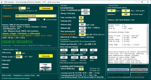
DMC III sensor type changed to CMOS -
bugfix compatibility to Windows 7 & XP users -
Leica ADS 100 – SH 120 included -
Imao B66 included -
PhaseOne IXU 1000 100 MP included. -
DMC III intermediate image size corrected (Thanks to Kenneth)
previous updates:
- Leica Geosystems CityMapper-2L
- PhaseOne PAS 880i
- DJI Phantom 4 RTK
- DJI Phantom Mavic 2 Pro
- Quantum-Systems Trinity F90+ w/Sony Sony RX1R II
- Quantum-Systems Trinity F90+ w/Sony UMC-R10C
- UViRCO CoroCAM® 8 UAV
- Aerialtronics Pensar
- Phase One iXM-RS280F
- Phase One iXM-GS120
- Teledyne Optech CM-11K Aerial Camera Module
- Phase One iXM-GS120
- Teledyne Optech CM-11K Aerial Camera Module
- Updated to Microsoft Net v. 4.8o
- Update check is back to working condition
- Leica GeoSystems Content Mapper
- Vexcel Imaging Condor 4.1
- AOS-P6 & AOS-P5 from ats-Berlin
- PhaseOne PAS880 Oblique & Nadir System inclination angle of oblique lowered to 42° (thx to Poul from Norway)note (still beta, inclination for foward/backward may be adjusted again, since it seems thats different, stay updated)
- DJI Zenmuse P1 camera included (thx to Nozer from India, change to 50mm lens in box „cal. focal lenght“)
- estimated time for „survey turn“ reduced to more common 3 minutes turn in PROPOSAL SECTION to produce more realistic estimations for quick proposals (Thx to Kornel from Poland).
- Will make proposal section more comfortable in future, so in case you have some ideas, please let me know.
- PhaseOne Oblique system is on test, your valuable remarks are always welcome
- PhaseOne PAS880 Oblique & Nadir System introduced (thx to Poul from Norway)
- Vexcel Ultracam Osprey 4.1 (parameters refined, esp. FOV and pixels, thx to Frank from Germany)
- DJI Zenmuse 3 system included (thx to Eduardo from Spain)
- since there are a variety of sensors, I have introduced a ComboBox „Manufacturers“ for better selection of the right system help and other links to Website using now your Windows default browser, e.g. Edge, Chrome, Firefox instead of the Internet Explorer
PhaseOne Oblique system is on test, your valuable remarks are always welcome
- Vexcel Ultracam Osprey 4.1
- PhaseOne 280MP
- Sony Alpha ILCE-A7R II – bug removed, thanks to Yanning from China
- IGI_DigiCAM-450 (PhaseOne 2019)
- IGI_Dual-DigiCAM-200 (PhaseOne 2019)
- IGI_Dual-DigiCAM-300 (PhaseOne 2019)
- Leica CityMapper-2 High-Performance Urban (hybrid) Mapping Sensor
- CityMapper-2 S & CityMapper-2 H separated (Thanks to Poul)
(note: you may always change focal in field „Cal. Focal Lenght“)
- IGI_DigiCAM-450 (PhaseOne 2019)
- IGI_Dual-DigiCAM-200 (PhaseOne 2019)
- IGI_Dual-DigiCAM-300 (PhaseOne 2019)
- MicaSense RedEdgeM/MX (Multispectral) (thanks to Eduardo y Alejandro)
- MicaSense Altum (Multispectral)
- IGI DigiCam 150 included
- IGI UrbanMapper – 2 final (change oblique sensor size)
- bug fix for Leica ADS100 using SH100 sensor head (thanks to Valentin of Leica)
- bug fixed showing wrong altitude of flight @ Vexcel Ultracam Falcon Mark II (thanks to Paul [Jacobs])
- Oblique Camera Calculation for Ultracam Osprey Mark 3 Premium /Essential
- IGI UrbanMapper-2 (preliminary)
- PhaseOne iXM-RS150F/ iXM-RS100F (150 / 100 Megapixel)
- improved for Windows 7 users.
For diehard Win 7 users, which refuse to move to Windows 10, we improved stability under Windows 7 to allow these users to participate on the latest version of the GSD Calculator. (Microsoft is no longer delivering feature updates to Windows 7, but will continue to support the operating system with security patches until 2020. Windows 8.1 mainstream support ends in 2018.) - changed pre-defined focal lengths for Ultracam Eagle and Falcon users, since most used focal is 100 mm (thanks to Roger of GRW & Paul of Jacobs)
- other improvements (thanks to Travin of Kisik)
- UltraCam Eagle Mark 3 updated
- Hasselblad A6D introduced
- UltraCam Eagle Mark 3 with 26,460 x 17,004 pixel introduced
- Phase One iXU-RS1900 Dual Lens introduced
- Samsung NX-1000 included for Daniel from CZ
- Sony Alpha ILCE-A7R II
- HySpex VNIR-1800 Hyperspectral sensor
- Installation routine changed
- Ground Speed Warning updated (see help, thanks to William of Sao Paulo)
Ground Speed Warning was not updating when GSD changed
- IGI Quattro-DigiCAM-400
- IGI Quattro-DigiCAM-300
- IGI DigiTHERM-1920-C
- IGI DigiTHERM-1280-C
- IGI DigiTHERM-640-C
- IGI Penta DigiCAM-100 [Center]
- IGI Penta DigiCAM-80 [Center]
- 6-DAS-1 (Wehrli)
- 4-DAS-1 (Wehrli)
- 3-DAS-2 (Wehrli)
- 3-DAS-1 (Wehrli)
- Ultracam Falcon prime (Ultracam Falcon Mark II) updated (thanks to John from Pennsylvania)
- Visionmap MIST IT
- Visionmap MIST U
- Visionmap MIST G
- IGI UrbanMapper
- IGI Digicam 100
- naming conventions for Ultracam
- more Help (ToolTips) included, move mouse over button/fields
- Ultracam Condor included
- IGI PentaCam updated
- Nikon D810 + Sigma 30 mm lens (for Raja & Leo)
- CS-1000 70mm lens included (for John)
- Ultracam Falcon bugfix (thanks to Gianluca)
- DMC III sensor type changed to CMOS
- bugfix compatibility to Windows 7 & XP users
- Leica ADS 100 – SH 120 included
- Imao B66 included
- PhaseOne IXU 1000 100 MP included.
- DMC III intermediate image size corrected (Thanks to Kenneth)
